Demeter
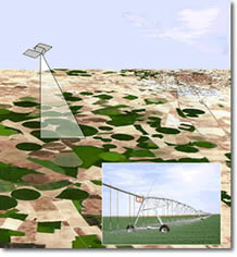
 DEMETER (DEMonstration of Earth observation TEchnologies in Routine irrigation advisory services) is designed to assess and demonstrate in an operational perspective how the integration of Earth Observation (EO) techniques in routine Irrigation Advisory Services (IAS) can improve the efficiency in the use of water for irrigation. The use of new Information Society Technologies (IT) in the generation and distribution of information will make the EO easily available to IAS and the farmers (the end users).
web: http://www.demeter-ec.net
Background
Irrigated agriculture is the main water consumer in Europe and large parts of the world. Therefore, it is the key strategic focus for efficient water use on a global level. To a varying extend, water availability is a problem shared by all European Mediterranean countries. Member State governments and the European Commission are issuing directives, emphasising the urgent necessity of efficient use of water resources. At the same time, these directives are calling for tools to aid in sustainable water management and for operational monitoring systems to assist in planning and control of water resources.
Irrigation Advisory Services are the natural management instruments to achieve a better efficiency in the use of water for irrigation. IAS help farmers to apply water according to the actual crop water requirements and thus, to maximise production and cost-effectiveness.
Approach
The DEMETER prototype is conceived as an integrated observing system, assimilating space and ground data and numerical models in a Geographical lnformation System (GIS) environment enhanced by IT tools.
DEMETER mimics the FAO approach by providing EO-derived crop coefficients, which is based on mature EO technology and is directly usable by the IAS. Maps of crop water requirements are obtained from applying the FAO crop coefficient methodology in a GIS framework. From these maps, spatial information (general and personalised) can be provided to the end-users by means of IT tools.
DEMETER will overcome the space-time resolution problem so far associated with the use of EO data in irrigation management by using data from all existing high-resolution satellites (ASTER, IRS-C, IRS-D, Landsat 5-7, Spot 1-2-3-4) in a virtual constellation, based on a new inter-satellite cross-calibration procedure. ln a second step, advanced EO-derived products on more detailed crop vigour, water stress, and irrigation performance monitoring will be developed and proposed for next-generation IAS.
Using this full set of high-resolution satellites, will allow us to obtain a revisit time of interested area of 1-5 days. The resulting average resolution of 4-5 days is sufficient for IAS operations in general, which are based on weekly cycles.
Thanks to DEMETER we will be able to obtain some different products from EO data. We can distinguish three different categories of variables:
canopy geometrical and spectral parameters: Fraction of Photosynthetically Active Radiation (FPAR), Leaf Area Index (LAI), Crop Coefficient (Kc)
irrigation management parameters
water status related parameters, such as canopy water content, water stress indicators, actual evapotranspiration (ET) and evaporative fraction
DEMETER is user-driven and policy-oriented. The presence of Local Users and National Users as team members, along with academic institutions and industry, helps to bridge the common gap between research and practice in the use of Earth observation in water management.
DEMETER is linked with global standards and EU policies through liaison persons from the FAO and the Directorates of Agriculture and Environment of the European Commission, who are members of the project’s Advisory Board.
Expected results
Easy availability of EO-derived information to the users is an important step to be achieved through a strategic synthesis of EO and IT. The IAS are the key information provider that will produce maps of crop water requirement (ideally as layer of a GIS) and distributes that information to the farmer in a personalised way, and to the general public (of free access). The personalised distribution and dissemination of the information to the farmers will range from conventional telecommunications channels to new media tools such as internet, wireless communication tools, etc., with specifically designed front-ends for quick and easy information visualisation and retrieval. In the long-term, DEMETER is seen as a timely contribution to the inter-related issues of raising water productivity (“more crops per drops”), enhancing rural development (“more jobs per drop”), and guaranteeing a sustainable agriculture, which makes it relevant for:
the Water Framework Directive,
the Common Agricultural Policy,
the Rural Development Policies.
There are many benefits rising from this project and related technologies:
rationalization of the water consumptions,
more detailed crop and irrigation performance monitoring,
improvements in the quality, quantity, timeliness and cost-effectiveness of information on crop water requirements.
Specific fields of expertise
GIS
Remote Sensing
Wireless integrated devices
Project developed by Mestor snc. Results and skills transferred to IES Solutions.


